Sunday, September 11, 2016

Urban nature: wild by plan


With the emphasis on the environment and battling climate change in the urban environment, the functionality of open green spaces is changing. In both new developments as well as the existing (sub)urban landscape space needs to be allocated for water retention as a result of climate change. Places that are flooded from time to time develop a particular vegetation.  Also studies have found trees to be beneficial in reducing pollution, especially atmospheric particulate matter. This results in the planting of trees especially along roads. Roadside verges are being converted from mown grass into bee ribbons supporting insect life. In other places wild flower mixes are sown to create visual interest (and also showcase the environmental credentials of the local authority).


On dry or sandy soils a different seed mix is used. Directly after sowing annuals like the Poppy (on the left: Papaver rhoeas) are the first to bare flowers. These are included for instant effect. Biannuals flower in the second -or sometimes third- year and will quickly establish on barren soil and develop a ground rosette of leaves. A beautiful example is the Viper's bugloss (Echium vulgare), shown on the right flowering at the top of a bank along an infiltration hollow used to store excess rainwater. Ultimately perennial wildflowers will dominate the vegetation. In the middle a combination of Oxeye daisies (Leucanthemum vulgare), Bird's foot trefoil (Lotus corniculatus) an Red clover (Trifolium pratense) thriving with several types of grass on moist sandy soil.


On loamy or clay soils different plants will thrive, so a different mix of plants is introduces. What germinates and grows well in the specific situation depends largely on the availability of moisture. On wet rich soils -shown left- Comfrey (Symphytum officinale) will dominate together with the Meadow buttercup (Ranunculus acris) and Cuckooflower (Cardamine pratensis) that flowers earlier in the year with pink or white flowers. In shady spots especially under trees or along hedges or in coppiced woodland Cow parsley (Anthriscus sylvestris) can dominate at the height of spring -as shown in the middle. Along roadsides narrow strips of land are sown with wild flower mixes to encourage wildlife especially bees and butterflies. Here an example of such a "bee ribbon" with Oxeye daisy and Cow vetch (Vicia cracca).


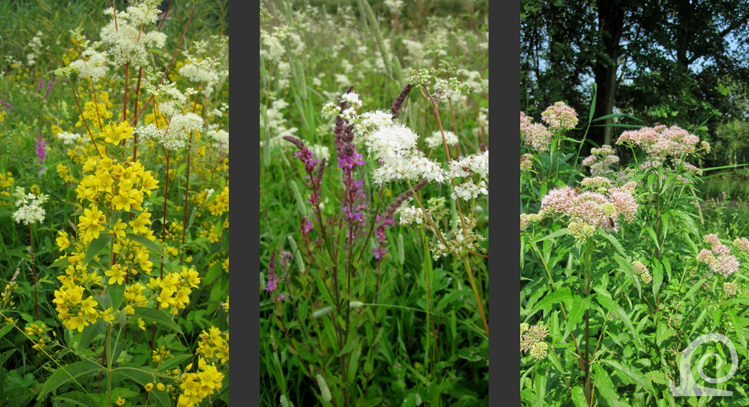
Rich wet soils are often regarded as of little ecological value. With careful planning and the application of the right seed mix some lovely results can be achieved. The Meadowsweet (Filipendula ulmaria) feels right at home on heavy, even waterlogged, soils. The creamy white flowers are loved by bees and humans alike. The plant often grows together with Yellow Loosestrife (Lysimachia vulgaris) on the left, or with Purple Loosestrife (Lythrum salicaria). A plant indicative of high nitrogen availability is Hemp-agrimony (Eupatorium cannabinum) with its pink flowers above finely cut leaves that resemble Hemp, hence the name.

Tuesday, September 6, 2016

Westerpark, Breda: sustainable urban drainage in practice


As part of the eco-inclusivity of the development the Westerpark Estate has one of the first custom-designed sustainable urban drainage systems. Urban drainage is viewed not as a separate system in the Netherlands, but the regional water boards (Waterschap in Dutch) demands local government to provide a so-called "watertoets" (= water check, although hydrological impact assessment would be a more accurate translation) for every spatial development, as the effects of the proposed development have to be compensated hydrologically. These water boards are a separate tier of government independent from central and local government. They have their own elections and also enforce their own laws and taxes.


A view across a remnant of the original rural landscape, looking towards the railway tracks connecting Breda with Rotterdam and Antwerp. The original landscape was a patchwork of small fields and meadows interlaced with streams. One of these streams is still winding through the landscape here, the other sections of this stream have been incorporated into the housing estate of Westerpark.


Apartment blocks line the street that forms the old edge of Tuinzicht and mark the outer edge of the former green belt that began here. These flat buildings are new and have been used to up the number of residents and create a denser central area in this suburban section of Breda.


Behind the middle-rise apartment blocks the Westertuin -a small park- stretches towards the new ring road beyond. almost half is taken up by a large artificial lake. This body of water acts as a buffer that stores rainwater in case of torrential rains. An elevated esplanade on both sides acts as an embankment to prevent flooding if the lake might overflow.


Directly adjacent to the park is a row of apartment buildings. In front is a main road and a car parking facility (a seen on the right). Here the residents overlook the park from their windows. At the back these buildings look out over a large stretch of grass planted with trees. The architecture is typical of the building period (1996-2001) with lots of angles that are now possible with computer aided design.


A view across the artificial lake towards the east with the apartment blocks on the edge of Tuinzigt clearly visible on the horizon. The lake has great value for wildlife. This was intentional, the design of this lake incorporates "nature friendly margins" planted with reeds and other aquatic plants. These also help to keep the water clear.


The artificial lake at the heart of this neighbourhood park combines nature and play. Some parts are inaccessible and are reserved for wildlife. In other places the water has been made accessible , for instance by this jetty (on the right), from where you can take to the water in a rowing boat or a canoe.


From the artificial lake, which incorporates part of an old streambed, the stream proceeds as a drainage canal, that is also used to store water when it rains heavily. The two rows of trees on either side make it a formal reference to urban canals. The loose vegetative margins however create a rather more natural feel in keeping with the suburban surroundings. The housing on either side has been built in long terraces.


Again the buildings have a style of architecture typical for the period. These are more expensive mid-range houses for owner-occupants. More interesting is the way this "canal" has been designed. Sloping lawns and low gabion walls allow the water level to rise above the "normal level" that is maintained by a small weir. The natural edges with reeds provide a nice contrast with the adjacent lawns.


This prominent apartment block is situated at the end of the "canal" in a bend of the stream. The stream is also widened here to reflect the building, and increase the capacity for water retention (a few centimetres over a large expanse of water can create more water storage than more centimetres over a stream).


Like most housing estates in the Netherlands, through-traffic is discouraged or even made impossible in the layout of the streets. For slow traffic like pedestrians and cyclists the shortest route should be possible. From the cycle path along the ring road this cycle path connects to a suburban street making the street a dead end or close. Cyclists can have a quicker and more convenient route. This is a simple way of stimulating cycling and walking.


In the northern half of this housing estate the soil is higher and rainwater can more easily drain away into the soil. To aid this large expanses of grass have been incorporated to allow for this. In this the wide grassy verge planted with Himalayan birch trees.


In contrast the housing in the southern section of the estate was planned on low-lying soil with many ditches. The ditches were filled-in prior to development, so other means of infiltrating and draining away rainwater falling on roofs and paved surfaces had to be provided. So here the green areas are rougher, more natural looking. They also have an ecological function and are maintained as flowering meadows. Mostly very common species of flowering plant like this Tansy (Tanacetum vulgare), are growing in these grasslands.


An example of a housing alley with apple trees planted on either side in grass verges. The houses beyond are special as these are a variation of the Mulhouse Quadrangle, a housing type typical of mining colonies and pre-garden city factory housing.


Some plants thrive in the conditions created by the urban drainage ditches that are dry for most of summer, but fill up with water on occasion. In some places the actual gully can only be distinguished a s a slight depression and a slightly differently coloured band of grass. A wooden walkway lets pedestrians cross the gully even when it is full of water.


Another housing alley with at a right angle to it another infiltration gully or ditch clearly visible as a band of yellow grass. These infiltration gullies run in between the houses, often along the streets. Rainwater falling onto the roofs and the paved areas is directed towards these infiltration facilities. When the amount of rainfall is greater that the infiltration capacity of the soil the gullies fill with water. Thus the water can be stored here temporarily.


In some places the gullies are part of a wide public green space plated with suitable trees. These willows (*Salix alba) don't mind growing in wet soil, but can also withstand dryer conditions. o these trees are ideal for a situation with strongly fluctuating (ground) water levels.


The old Emerweg (has been converted to a wide cycle path, the new road has been built beyond. That way the pollarded willows ("knotwilgen"), a common feature of Dutch polders, could be retained in situ. The agricultural drainage ditch that ran along the former road has been widened and incorporated into the sustainable urban drainage system of the Westerpark Estate.

Sunday, September 4, 2016

Westerpark, Breda: an example of sustainable urban development


The fortified watercity of Breda lost its defensive role due to changes in methods of warfare. So in 1870 the fortifications were dismantled. This freed up a lot of space around the very dense urban core. The moats were filled in and levelled with soil from the ramparts. City gates, walls and bastions were torn down and some roads were widened. Van Gendt planned the change from city defences  into wide boulevards with villas.

As the city limits only reached to the edge of the field of fire around the fortifications, the city officials, eager to realize large-scale expansion, looked beyond at the neighbouring villages. It would take until 1927 before the villages of Princehage (= The Prince's Hague), Ginneken and a large part of Teteringen (The Polder Hoge Vught and Heusdenhout) were annexed by the central city. The local council had already had plans drawn up so building work started immediately. One of the new housing estates built was called Tuinzigt (= Garden View) named after a mansion of the same name located not far from a Kolfbaan (= Mall). The estate was developed as part of the Plan Schaap, a plan for urban expansion beyond the old city limits drawn up by an urban planner from Arnhem. Building work started in earnest in 1935, although the first streets had been developed in 1920 (within the old city limits), 1927 and 1931. Further additions were completed in 1948 and 1963. After that a 30 year moratorium on development was agreed. Thus the area west of Tuinzicht remained a lovely rural fragment within the city with scattered farms, some houses, fields, meadows and hedges.

This idyll wouldn't last, of course, as developers -with the moratorium in mind- were buying up land from 1990 onwards. The local council and central government with the standing planning policy of concentrated urban development earmarked this "unsightly semi-rural mess" as key strategic development area. At the same time plans were being made for a high-speed railway line linking Amsterdam and Brussels via Antwerp. The preferred route ran along the motorway west of Breda and required vast changes to the local infrastructure. These forces combined resulted in the development of the industrial estates of Steenakker and Baanzicht, the housing estates of Heilaar and Westerpark, and the Kruisvoort Shopping Mall. Only the hamlet of Overbroek remains as a densely built up winding street that in bound on all sides by industrial estates, the railway, the motorway and the eastern edge of the commuter village of Prinsenbeek (= Prince's Brooke).


The city of Breda comprises of the historic urban core (B) within the former city moat that was transformed into a strolling park with tree-lined belt road with adjacent the formerly independent villages of Teteringen (T), Dorst (D), Bavel (Ba), Ginneken (G), Prinsenhage (Ph), Prinsenbeek (Pb) and Terheiden (Th) and the large urbanisations -comprising of several housing estates- of Hoge Vugt (Hv), Haagse Beemden (Hb) and Heusdenhout (H).West of the housing estate of Tuinzicht (1) the Esterpark Estate (2) is situated with the Heilaar Estate (3) and the employment areas of Steenakker (4), Baanzicht (5) and Kruisvoort (6).

In the spring of 1996 work started on the new housing estate of Westerpark. This was the first such estate in Breda to be developed with maximum emphasis on durability and the environmental impact. This focus was a was aimed at generating agreement from local people who -rightly so- contested the decision to not renew the moratorium on development, as they greatly valued their greenbelt. As a result a park was included and there was an emphasis on increasing the "natural value" of the area by creating specific habitats and building a sustainable urban drainage system incorporating several streams that already ran through the area. The result was an example project, however it is much less coherent than "In Goede Aarde", a later similar development. The Westerpark Estate was developed as an annex to the Tuinzicht Estate, and has no amenities of its own.

To emphasize the ecological aspect of the development the name Westerpark (=West Park) was chosen. In addition all the street names have been named after butterflies. Some  of teh housing isn't located on a suburban street accessible to car traffic but on a so-called "woonpad" (housing alley) that is only accessible to slow traffic i.e. pedestrians and cyclists.

The Westerpark Estate in Breda is a large housing estate with both terraced housing, a few semidetached houses and villas, and flats in high apartment blocks. It is an excellent example of the mixed standard of Dutch housing estates with 34% social rented, 25% affordable and 41% more expensive (aimed at middle-income couples, so by no means upper-end). Some 3.500 people live in 1.400 houses and flats. The layout is fairly typical of Dutch urban design of the period, with housing with a postmodern flavour set along streets or in some cases aggregating around small public greens. Building height varies, so does the colour of the building materials and the roof shapes. Thus several neighbourhoods can be distinguished, each with its own set of characteristic architectural features. Another distinct feature is the excellent permeability for slow traffic combined with no through-traffic for cars in every neighbourhood. These features in combination with a rather contrived mixing of terraced housing and "linked semidetached houses" has been a feature of urban design in the Netherlands since the late 1970s.


The Westerpark Estate comprises of two sections, north and south of a central park (P) with a large artificial water retention lake (L). A stream runs through the estate -partly as a formalised canal (C)-connecting it to the complicated water system in and around the city of Breda. In the southern -more low-lying and thus originally wetter- section provisions had to be made to compensate for the loss of hydrological buffer capacity after development. Here a system of gullies (in light blue) were excavated that fill up with rainwater that in part drains away into the soil replenishing ground water levels, but in extreme weather conditions can be directed towards connected water courses. The new ring road (R) forms the boundary of the estate on the west side. Two pre-existing farms (f) were incorporated. A very notable feature is the inclusion of two rows of postmodern reinterpretations of the Mulhouse Quadrangle (M).

Thursday, August 25, 2016

Urban nature: at home in the city


There are plants that thrive in the (sub)urban environment and can be seen growing in unexpected places. Some of these plants are adaptable species that exploit favourable growing conditions. Sometimes even so much so that they are considered a weed. Other plants can be found happily growing in the urban environment whilst botanists know them to be specialists of a particular growing environment. Some of these plant can be -locally-abundant in the (sub)urban environment whilst very rare in the wild. Urban Areas are now also included in the list of flora districts or habitats of the Low Countries.


Rosebay willowherb (Chamerion angustifolium) is known in America as Fireweed as it's often one of the first plants to reappear after a forest fire. The large flowers are followed by pods that produce large amounts of tiny plumed seeds that drift on the wind and float on water. It has a preference for damp to wet soil and is associated with disturbed ground. Here (shown left) it grows happily in a cracked concrete driveway. Throatwort, or the Nettle-leaved bellflower (Campanula trachelium) is a beautiful plant of woodland edges that was once abundant in coppiced woods. As that practice has been mostly abandoned the plant has become rare in the wild. Sometimes it can be found in a suburban setting in humus rich corners in cool shade. A close relative, the Creeping bellflower (Campanula rapunculoides), can be found growing along the side of pavements against north-facing facades. This perennial, that naturally thrives in the dry shade of woodlands and hedgerows, spreads by underground runners and can become a weed in gardens. It is a protected and rare species in the Low Countries, but has become established in several cities.


Typical woodland species can become very abundant in urban parks, graveyards and gardens. Hedge woundwort (Stachys sylvatica) grows naturally in hedgerows and in the dappled shade of the woodland edge. It can become abundant in parks on rich soil (shown left). Another indicator of rich soils is Ground-ivy (Glechoma hederacea), an evergreen ground cover that isn't related to Ivy but  rather to Woundwort and Sage. It thrives in moist shady areas, and will invade the sunny turf of a lawn given sufficient moisture. Enchanters' nightshade (Circaea lutetiana) is another species normally found in moist woodland on rich soils. As it tolerates deep shade it is often found in 19th century parks that have become overgrown and as a result densely shaded.