Showing posts with label Brussels. Show all posts

Thursday, December 7, 2017

Cité-Jardin Kapelleveld: Avant Garde housing in shades of grey


The garden village Kapelleveld at Woluwe-Saint-Lambert near Brussels is an example of a modernist interpretation of the garden city model, here translated into a garden suburb or suburban garden village. The housing is mostly modernist, with a small section in a traditionalist style. The housing with the flat roofs and the dark roof trim is similar to that seen in La CitéModerne, another modernist garden village near Brussels.


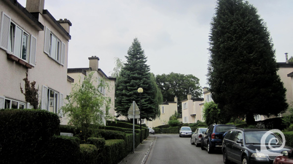
Of the three tree-lined avenues two remain. The central avenue has a tram and the southern avenue has a garden-like central reservation. The northern avenue was never replanted after WW2. Cars and parking now dominate the edges. As this avenue was intended as a major thoroughfare the dimensions can handle present-day traffic.


In the 1950s some blocks of terraced housing were added along the Avenue Albert Dumont. This housing by Paul Posno (right) is similar in size to the original housing (left), but much less detailed. Also the block is treated less sculptural and the proportions are much less harmonious -the blocks are evidently not designed with asset of harmonious proportions in mind. The Avenue Albert Dumont was named after an architect of French origin who is well known for designing many villas and cottages, especially on the Belgian coast. He was also one of the promotors of the Garden City Movement in Belgium.


The original housing was arranged along kinged streets that ran off the avenues at a right angle. The side walls form the entrances to the residential streets. This way of separating street along function is common in New Objectivity housing in the Benelux and Germany.


The kinked street marries the ideal of short view creating a sense of place which fits nicely with Sitte-esque design theory and the Unwinesque elaboration of it. Apart from this the garden village at Kappelleveld has no typical features of the Garden City Movement aesthetic.


The blocks of terraced housing are sculptural compositions with a strong cubist aesthetic. The short chimneys at the corners of the main blocks are used in a decorative way to break the flatness of the roofline which is emphasised by the black wooden trim. The staggering of the building line is very effective and creates a pleasant flow along the street.


Another type is basically a modernist semidetached house with protruding sections at the corners, reminiscent of standing bays. In places this type has been linked to form row housing (left). The design plays with verticality and horizontality with the narrow high windows at either end and low and wide windows in the middle.


The standard type with the low chimneys all have rendered facades. The colour can vary from off white, via light grey (on the left) to dark grey (on the right at the front). The wooden trim is always painted black to unify the sculptural blocks in the streetscape.


All housing has a front garden. In true garden village style these gardens were edged by a hedge. Here privet was used. All gardens were made uniform by using a similar green edge. Sadly the hedges have bene removed in places, or have bene replaced by hedges made from a different plant species (mostly beech and box). At the end of the streets the orange clay tile roofs of the intermediate section are just visible.


The southwestern section of the garden village was designed in a mixed style with pitched roofs covered in clay tiles above cubist blocks. The result is an Avant Garde marriage of the traditional and the modern. All the facades are rendered, with wooden trim in black and white. The chimneys are practical and not used as a decorative device. The bays and dormers are used in that way however.


The intermediate housing has flat dormers with a protruding roof directly above the window frames. Al woodwork of the doors and windows is painted white, as well as the underside of the eaves (right). The front of the box gutter is painted black. The awnings above the front doors are treated similarly.  


The contrast between these two sections is remarkable. This makes that the garden village Kapelleveld is defined as three neighbourhoods by the architectural expression of the buildings. The central core is modernist, sculptural and cubist, the southwestern section is Avant Garde mix of traditional and modern and the southeastern section is traditionalist with a sculptural treatment of the facades in brick.     

Monday, December 4, 2017

Cité-Jardin Kapelleveld: a modernist interpretation of a garden village


On the rural outskirts of Brussels several small villages were to be found. Sometime in the 11th century the wood around the river Woluwe was cut down on the instigation of Park Abbey in Louvain and was administered by the Benedictine Abbey at Vorst (Forest). In the twelfth century the area was spilt into two parishes Woluwe-Saint Pierre and Woluwe-Saint-Lambert, each named after the respective patron saint (Peter and Lambert). The villages were located on the edge of  a narrow river valley at the foot of a large fertile plateau, hence the French name Montagne aux Sols (mount of the fertile soil). The Dutch name Kapelleveld relates to the nearby Chapel of Our Dear Lady of Sorrows (Maria Dolorosa) that was in part funded by a tithe of these fields.

After WW1 the housing need in Belgium peaked and the National Society for Cheap Housing and Dwellings (Nationale Maatschappij voor Goedkope Woningen en Woonvertrekken) was founded in 1920. This national building promotor realised that the disused fields near Wolume-Saint-Lambert were ideal for the realisation of a garden city inspired suburban development. So in 1922 the Cooperative Society ‘La Cité-Jardin du Kapelleveld’ was founded with the aim to build affordable housing near Brussels. The NMGWW provided government-backed low rate loans to local building coops.

The building coop employed Louis Van der Swaelmen to draw the plans for this low-density suburban development. He retained the height differences of the original terrain and designed a housing district as a fan of tree-lined streets interconnected by side streets and two separate features (am undulating avenue and a triangular garden square) at the southern edges of the oddly shaped site. The layout of streets has great affinity with garden design of the time. 


The garden village designed by Van der Swaelmen has a rather odd layout which is a mix of formal radiating fan of streets with kinked and curved streets connecting to these. His original design included  two closes (c) that were never built, a school (s) a church (+), a football stadium (fs), a tennis club (tc) and football pitches (fp). The circles between the gardens were designed as playgrounds. The easternmost section was executed in a different style of architecture with pitched roofs and brick facades (yellow outline). The rest was executed in a modernist style with flat roofs or pitched roofs with clay tiles (orange outline).

The housing is placed rationally along the kinked side streets. The three radial streets of the fan all serve as thoroughfares. Thus the plan has affinity with New Objectivity. This can also be said of the housing in most of the development which is designed in a sculptural cubist modernist idiom. The eastern section, however, has buildings in a traditionalist vernacular idiom. Thus the whole feels like a compromise -much like Tuindorp Watergraafsmeer near Amsterdam- especially with the expansion east of the Ideaallaan (Avenue de l‘Idéal) after WW2 with piecemeal sections of rather random streets lined by brick-built semidetached and terraced housing and brick-clad low-rise apartment blocks.

Building density is low compared to the Brussels average. Great attention has been paid to planting trees and providing residents with a front garden and an ample back garden. Leisure facilities were also incorporated in the plan with tennis courts, a football stadium with some practice pitches and several playgrounds. Several architect (Antoine Pompe, Huibrecht Hoste, Jean-Francois Houben and Paul Rubbers) collaborated in the design of over 400 houses in 19 different types. Ten houses were equipped with a shop room at the front. All housing was built between 1922 and 1926. The suburb was designed as an independent social entity with communal spaces such as a library, shops, community hall, sports facilities, office for the cooperative, school and church. The last two wouldn’t be built until later. In the Arthur André Street a station on the Brussels-Tervuren railway line was opened. The coop employed Paul Posno to design the 1951-71 expansion. Also some blocks were added as infill. In 1968-69 some streets were extended southwards and some housing was added.


The changes and later additions have changed the garden village around the edges. This makes the whole even more of a compromise than originally intended. Along the Avenue Albert Dumont blocks were added along the street. The large gardens on the south-eastern side were developed with terraced housing. A church was built in stead of the school and where a church was envisaged a school would be erected. The sports facilities have been altered with some buildings built on the edges (a school and a centre for handicapped children). The additions have little spatial and architectural merit and are rather incidental.

Kapelleveld is one of the garden villages (or Tuinwijken / Cités-Jardin) that were built around Brussels. The houses were constructed with cinderblocks (or breeze blocks), a light-weight concrete construction element made up of a mixture of ash, sand, water and cement. The facades are rendered with a wide trim in wood at the top. The colour of the outer walls varies from an off-white via light grey to dark grey. As an Avant Garde enclave the housing of Kapelleveld is still recognisable in the urban chaos that is Greater Brussels. Although inspired by the Garden City Movement, this suburban enclave has none of the Sitte-esque features of German and Dutch garden villages, nor any of the Unwinesque features characteristic of British examples. It is basically a modernist interpretation of the type.

Thursday, March 26, 2015

Conscious capital beautification: axial intervention in Brussels


The largest city of Brabant became the new capital of Belgium in 1830 after the split of the post-Napoleonic United Netherlands. Brussels was a certain choice as an important historic city centrally located within the Dutch speaking part of the young Belgian State but importantly with a strong ruling class of francophones. As the largest city within the historic Duchy of Brabant, Brussels was a large fortified city, although it had plenty of space within its defences at the time it became the new capital of Belgium. This old city was characterised by the often winding streets and alleys. The new king Leopold I (a German Prince by birth) ordained the beautification of his new capital and in 1831 work started on dismantling the walls and earthworks. The former glacis was transformed into an ample boulevard for carriages lined with 4 rows of trees. The area within is henceforth known as the Pentagon (Vijfhoek in Dutch).

Modelled on Paris, new roads were cut through the medieval clutter of streets and buildings from about 1850 onwards. The old city already boasted an axial intervention dating back to 1777 when the Rue Royal was laid out along the edge of the park of the Brussels Residence. The park was also remodelled and replanted. Across from the residence a Government building for the Brabant Council is erected between 1779-1783. Across from the new Warande Park (a warande is a small hunting park for pheasants, fallow deer and other small animals) the Dutch King William I has a new palace erected in 1820 not far from the site of the former palace of Koudenberg that had been destroyed by fire in 1731. After the independence of Belgium the old Council building is appropriated as the new parliament building known as the Palace of the Nation located on what is henceforth known as Law Street. The new King of the Belgians moved into the purpose-built palace that was expanded in 1877 to double its original size.

The first axial interventions beyond the Warande Park are located outside of the grand ring of boulevards. In 1837 work starts on the Leopold Quarter, a grid based high-status suburb directly east of the old city that is modelled on German examples in Dusseldorf, Berlin and Munich. The gridlines tie in with the layout of the Warande Park. In 1847 the Avenue Louise was built linking the city with the Forest of Cambre. In 1853 the Avenue along the Warande Park is extended beyond the Ring of Boulevards towards a new church. Along this extension the so-called Column of Congress is erected in 1859. Also within the old city, a large part of the Marollen Neighbourhood is demolished from 1860 onwards to create space for the enormous Palace of Justice on Gallow Hill. The building and the axis linking it to the Place Royal are completed between 1867 and 1883. Between 1868 an 1871 the Zenne river was culverted within the Pentagon and a new boulevard was built over it: the Boulevard Anspach that cuts through the medieval streets of the oldest urban core of Brussels.


The oldest axial interventions within the old city centre around the Warande Park (a) To the north of this formal park the parliament building (1) is located, opposite the royal palace (3). The first formal axis starts at the Place Royal (2) with the classicist complex of the Constitutional Court and the Church of St Jacob on the Mount.The Rue Royal continues from the park along the Column (4) and the Botanique, a botanical garden (5) to end at the church of St Mary (6).Directly east of the Warande Park lies the Leopold Quarter (b) with a (former) station building (c) at the end of the lowest street.

Behind the Leopold Quarter a large eponymous park was built between 1851 and 1854. Further north a high-class neighbourhood, inspired by London's Garden Squares, was built north of the Leopold Quarter between 1856 and 1872. Like the Leopold Quarter the axis lead from nothing to nowhere and are therefore not really axes but rather formal street plans that tie into the pre-existing pattern of streets and rural lanes.

Most axial intervention in Brussels are based on the 1862 plan of Victor Besme for the beatification of the capital city. The crown prince was very taken by his ideas. Thus in 1864 a plan for the creation of the Avenue Leopold II is passed by the city council. The idea was to expand the city across the Koekelberg Plateau west of the city. The axis that runs off the northern Boulevard is the central axis of this so-called Leopold II Quarter. Several imposing buildings were planned at the cusp of this axis: a Royal Villa (1864), a Palace of Industry (1866) and a National Pantheon (1879). None of these where built, instead the large Art Deco Church of the Sacred Heart was built in the elevated park from 1905 onwards.

To commemorate the Golden Jubilee of Belgian Independence in 1880, Leopold II orders the creation of a large Jubilee Park along a new formal avenue that was an extension of the important Law Street (Rue de la Loi) that runs between the parliament and the Warande Park. The terrain had been used for the manoeuvres of the City Guards. As part of the jubilation festivities a National Exhibition was staged in the new park with two large exhibition buildings designed by Gédeon Bordiau. Due to the enormous success of this exhibition, the park is enlarged and hosts the World Exhibitions of 1888 and 1897. It is with the 1888 International Contest for Sciences and Industry that the park becomes known as Jubilee Park. IN 1905 a large Triumphal Arch is built linking the two exhibition buildings. The structure with 3 arches is crowned by a statue of Brabantia in a quadriga and spans the central axis. As the point de vue of a secondary axis the large Mosque was built in a corner of the park in 1879.


The axial interventions after Besme are a continuation of earlier interventions that are seldom formalised with a beginning or end. One of the most contested axial intervention connects the Place Royal (a) with the Palace of Justice (2) via the Rue de la Régance (1) a formal street. The Avenue Louise (b) is both a beautiful street with trees as well as an improvement of traffic structure. The Leopold Park (c) is located on an extended formal street off the Leopold Quarter. North of this the extended Rue de la Loi (d) forms the central axis of the formal Jubilee Park with the exhibition halls (3) and the mosque (4).The Quartier des Squares (e) centres on the Square Ambiorix. Within the oldest parts of the city the Boulevard Anspach (f) lies over the covered Zenne river. It connects to the Boulevard Emile Jacqmain that leads to the Boulevard Albert II (h). Around the Gare du Midi a formal street - Boulevard du Stalingrad (g) - forms the centre of the Quartier Rouppe. The Grand Ensemble on the Koekelberg was inspired by Mont Martre. The central axis of Avenue Leopold II (i) is a continuation of the northern Boulevard d'Anvers and culminates in the large church in the Elizabeth Park (5). With the starlike formal streets that radiate out from this central point du vue this ensemble is known as Leopold II Quarter (j).

The area between the Leopoldpark and the Jubilee Park was developed as the centre of the European Union after WW2 and has changed dramatically with the addition of large office buildings that are places rather haphazardly within the older urban fabric.