Thursday, February 6, 2014

Water cities: a typology


Human settlement is often related to water. This can be the edge of a lake, a well, the bank of a river or the shore of the sea. As the availability of enough fresh drinking water is important for the survival of the species this is hardly surprising. As settlements developed some were granted a special status or surpassed other settlements because of a particularly favourable position. As these urban settlements grew they differentiated. Some cities grew naturally as a result of the cultivation of the area around it. Some cities grew as result of the foundation of a power base like an abbey, castle or high status residence. Other cities grew because they had been granted special rights, for instance to hold markets, to administer justice, to staple certain goods and commodities, to weigh goods, to mint coins, to tax passing traders, vessels and carts and to build defenses.

Some cities are located on the edge of the water, for instance on a lake, on the sea or on a large river. Other cities spread on both sides of a watercourse. This can be a natural river but also an artificial water channel (one only needs to think of the city of Delft). Often cities grew where a smaller watercourse joined a larger one; for instance a brook flowing into a larger river, a river flowing into the sea, etcetera. Some cities were built on an island. This can be a natural island (think of Manhattan), but also one or more artificial islands (Venice is the best known example).


Water cities can be characterized by their spatial relation to a specific body of water. There are waterfront cities that edge a large body of water like a lake, the sea or wide inlet or river. This type of water city borders onto the water on one side with parallel patterns on that side as well.


A more common location of a water city is on one or both sides of a watercourse. This can be a natural brook or small river, but also a manmade drainage channel or canal. These waterside cities can be located on high ground next to a river or brook, but also in the floodplain. Dam cities are a special category within the latter. Damming the watercourse regulates water levels behind it and can prevent frequent flooding when combined with moats and canals that encircle the urban area.


The third category of water city is also located along a watercourse, but specifically at the junction of two streams or canals. These water junction cities can be located at the junction of two streams of similar width or at the junction of a smaller stream with a bigger one. Such cities can be located on higher ground but also in the floodplain.


The last type of water city is surrounded by water on all sides. Such island cities can be located on a large single island or on many separate islands. These clusters of urbanised islands can be both natural (Stockholm) and artificial (St. Petersburg).

For many people a true water city has to have visible surface water present throughout the urban area. This means that waterfront and waterside cities on higher ground and cities on large islands are not seen as a water city but as a city by the water. Especially cities characterised as water junction cities, waterside cities in the floodplain -including dam cities- and cities built on several small island (especially when artificial) are to most people true water cities. For instance London (the City) is a city by the water and Rotterdam like all dam cities is a water city.

Monday, February 3, 2014

Amsterdam Bijlmer ArenA


The current station Amsterdam Bijlmer Arena started life as Station Bijlmer in 1971 on the Rhijnspoorweg between Amsterdam and Utrecht. Both the platforms and the station buildings were built in wood. Soon after it was decided to change the level track into a high track. In 1976 the new high track situated on an embankment was opened. Between the railway tracks two new tracks for the metro were built. In 1977 the new station was opened for the traveling public. It was the only train station on a main line not designed by a railway architect, instead is was designed as one of the stations on the metro line from the centre of Amsterdam to Gein. The bus station was moved to the east of the station to better connect to the elevated roads of Amsterdam-Zuidoost.


In 2000 work began on the third incarnation of the station under the new name Amsterdam Bijlmer ArenA. The number of tracks was doubled to 8, expanding train traffic to Amsterdam and also allowing for a direct connection to Schiphol Airport. The bus station moved back to its former location on the west side of the train tracks. From 2006 the new station was completely opened for all users. The new station is over 100 metres long and extends over the Arena Boulevard, the central axis of the leisure complex west of it with the Football Stadium of Ajax, the Heineken Music Hall, Ziggo Dome (a square box so a misappropriated name), Villa ArenA and the Pathé Cinema-complex. On the eastside lies the largest shopping centre of Amsterdam: Amsterdamse Poort.  

Thursday, January 30, 2014

Amsterdam-Zuidoost, big ideas on the modern city (part 3: urban renewal)


The radiant city of Amsterdam-Zuidoost was built for success. Large, light and spacious apartments in huge high-rise buildings set in a verdant landscape of parks with easy access by both car, bicycle, foot, bus and metro would form the basis of the new way of living in tune with the modern times. Unfortunately this urban utopia never really materialised. In part this was due to changing insights into social housing. The first hexagonal apartment buildings was completed in 1968, the last one in 1975. Over 13,000 flats had been built before the focus shifted towards lower apartment buildings -for instance Nellestein built between 1977 and 1982 on the edge of the Gaasperplas. The area never attracted the numbers of middle-class families envisaged by the planners. Most middle-class families preferred the new town of Almere, a planned community in the Southern Flevopolder started in the 1970s. Furthermore, following the independence of Suriname in 1975 many of its inhabitants migrated to the Netherlands. The government decided to place them together in the partly vacant affordable social housing of the Bijlmermeer (in the hexagonal high-rises). The area quickly became seen a s a black neighbourhood leading to a departure of white people and successful immigrants who didn't want to be associated with the low status and poverty for which Bijlmer was now a synonym. Later asylum seekers were also housed in Amsterdam-Zuidoost, making it a culturally very diverse but not less black area.

For years the problems of social segregation, high rates of unemployment and crime, and high number of inhabitants with social and mental health issues were denied and played down by local government. The change came when in 1992 disaster struck as an El Al plane crashed into Kruitberg and Groeneveen, two hexagonal high-rises. The official death toll is 43, including the three Israeli pilots, but due to the high number of illegal residents the true number of fatalities is probably higher.

In the aftermath of the crash it was decided that more needed to be done than simply provide for alternative housing for the residents of the two buildings destroyed by the plane crash. A new Bijlmer should arise from the ashes. After consultation and a variety of, both official and unofficial, plans it was decided to radically renew the area. The focus would be on the hexagonal high-rises with their parking garages and community spaces on the elevated streets.


The New Bijlmermeer focuses on the northern part of Amsterdam-Zuidoost where the Le Corbusier-inspired hexagonal high-rises have been for the most part demolished and replaced by new housing that is mostly terraced or takes the shape of apartment buildings. The urban renewal stretches from new leisure centre around the Amsterdam ArenA (A) via the Amsterdamse Poort shopping centre (P) and the new Anton de Komplein (K) along the Bijlmerdreef to include the areas where the hexagonal high-rises once stood. The parts of these still standing are indicated in red.

Within the area earmarked for urban renewal a leisure complex and football stadium, new shopping centres, new schools and 8,000 new homes will be developed. By 2010 5000 new homes had been built, mostly replacing the hexagonal high-rises. Two existing shopping centres in the undercroft of a parking garage have been demolished and replaced by the new Ganzenpoort and Kameleon malls. The Amsterdamse Poort shopping centre has been expanded. The schools have been integrated into a so-called Broad School (Brede School) combining a kindergarten, primary school, sport facilities, day-care centre, GP-surgery, health centre, community centre, etcetera.

The remaining flats will be renovated as the Bijlmer Museum. Much of the new housing consist of terraced family housing. Some new dwellings will be built in low-rise or high-rise buildings. The aim is to add 1,000 new homes on top of the 7,000 new dwelling built to replace the ones lost by demolishing the hexagonal high-rises. Special schemes aimed at retaining residents in the area by subsidising mortgages are in place. Most of the old residents will have to move on however, as urban renewal is especially aimed at increasing the number of middle-class families and higher income groups in Amsterdam-Zuidoost. In places the elevated road have been lowered. The idea(l) is to create a diverse and mixed suburban satellite.


The water system has been redesigned with the renewal of the area. More surface water was needed as parkland was built over and paved, creating less surface for water to seep into the soil. The new plan of Amsterdam-Zuidoost clearly shows the differentiated ideas by which the separate neighbourhoods have been redesigned.

New housing has been designed along themes, such as water, courtyard, garden patch, songbirds, colours etcetera. This leads to different solutions in different locations, making the whole of Amsterdam-Zuidoost a patchwork of neighbourhoods with different architecture, character and mix of housing types. There is little to connect these various ideas as the old connective devises of watercourses, rolling parkland and elevated roads have been abandoned and in some cases denied by obliterating them. However nice some of the new housing is, the whole feels like an admission of weakness by only envisaging the urban landscape as a collection of themed urban fragments with no interconnectivity or relation.

Morphologically the old grid still shapes the alignment of streets and buildings, but this is not visible on the ground only on the plan. Urban design is not about making an emblematic plan, but all about creating a recognisable and distinctive urban landscape that functions well on the scale of the neighbourhood as well as the conurbation as a whole.

Friday, January 24, 2014

Amsterdam-Zuidoost, obliterating the Radiant City


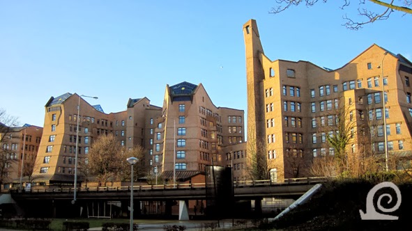
These offices of the former MBN Bank, now the head office of ING Bank, cradle the Amsterdamse Poort shopping centre. The design is characterised by an integral approach to building, inside space, environment and landscape. The office complex is comprised of a series of linked towers organized in an S-shape around courtyard gardens. Each tower has a basic elongated hexagonal footprint. In front of the offices one of the elevated roads is clearly visible.


Amsterdam-Zuidoost is beneath the flight path of Schiphol Airport. Every few minutes you see a plane come overhead. The distinct style of architecture by Alberts en van Huut sets these buildings apart from the uninspired architecture of the shopping centre behind it. In organic architecture buildings are seen as organisms with nature providing the shapes, measurements, principles and scale  that should be followed to tune the built environment to the human experience.


Where the temporary service centre stood until the 1980s a new neighbourhood was built in the 1990s. Before that time the area had been used for singing contest by bird enthusiasts. The name of the new neighbourhood commemorates this; Vogeljeswei literally means Little Bird Meadow. All the streets are named after bird species and thus don't follow the alliterative naming of streets within a neighbourhood. The terraced housing fills a part of the central strip originally designated for amenities.


An important feature of the original design is the total separation of through routes per mode of transport. Car traffic runs over elevated roads that fly over cycle paths and walking paths. Slow traffic is often combined in parallel paths that run at right angles to the elevated traffic roads. Large bodies of water crisscross the area. They are needed for water management, the area is after all a polder with a constantly maintained, artificial water level on a fixed gauge.


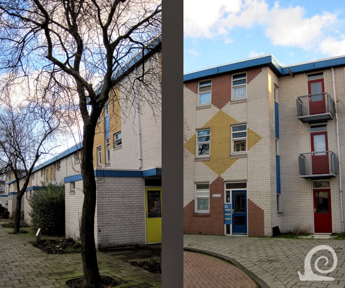
By the end of the 1970s the large scale apartment buildings were not looked upon very favorably anymore. The western half of the neighbourhood K was built with terraced housing and low-rise apartment blocks around communal gardens. So at the heart of the Bijlmermeer we find these buildings instead of the proposed high-rises.


The architecture is typical of the late 1970s - early '80s with low-cost materials used in such a way that the overall impression is somewhat playful. An easy way to upgrade the look of a building is by using colour in large blocks and brightly coloured doors and window frames.


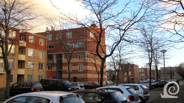
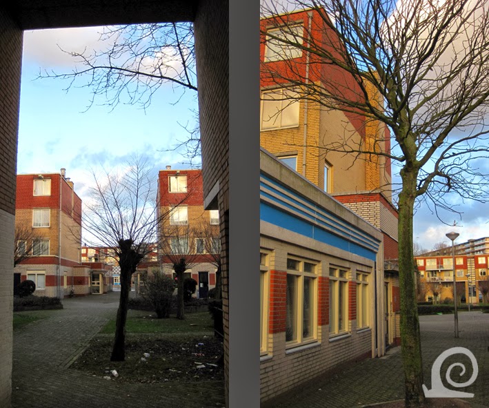
The architecture tries to be functional and use constructive elements as ornament. Parking was factored into the design of these spaces. On the inside of every apartment block there is a communal garden space with plants, benches and a play area.


These low-rise apartment blocks make up half of the 1980s section of the neighbourhood K. The 404 dwellings have been built in 1985 with public amenities included in the corners. A central axis with a walking path connects the various garden courts.


The bright new future of urban living was envisaged as high-rises set in continuous parkland with no traffic on ground level. With a ray of sun hitting the side of these hexagonal apartment buildings they don't look half as grim as people tend to view them. The apartments are spacious and the scale is enormous, so there is a great sense of open space.


The entrances are often slightly hidden. Here the entrance to Kikkenstein, one of the high-rises destined to remain. Some of the hexagonal building have been renovated with special attention paid to the entrances, making these more obvious and safer.


A view across the parkland in between the hexagonal high-rises. The elevated metro line runs through the middle of the picture. The park is only accessible to pedestrians and cyclists.


Along the Bijlmerdreef (that has been lowered east of the Gooisedreef) the parking garages have been demolished. The derelict shopping centre in the undercroft of one of these garages named Kraainest has been torn down together with parts of the other garages and high-rises. Here the old (white) in the new (red brick) blend well together, because the new buildings have a large footprint and comparable height.


Where the hexagonal high-rises have been demolished they have, for the most part, been replaced by terraced housing and low-rise apartment blocks. All of the parkland has been parceled off, leaving strips of greenery in places. The reuse of older park land in this way does give the new green structure a great sense of maturity.  


As everywhere in the Netherlands there is great need for parking space. In an urban environment this doesn't just apply to cars but also very much so to parking space for bicycles. Here they are parked right in front of these family houses. Along the central axis of the Bijlmerdreef the buildings are higher. They often have commercial space on the ground floor with apartments above. The style of architecture is similar with the use of the quintessential red brick.


A view along a new street with low terraced housing on both sides. All the roofs are flat. In places older trees have been spared during redevelopment. This picture, however, could be taken in any Dutch city.


The architecture is definitely of its time. These new terraces combining natural stone and wood are a good example of contemporary architecture. The same rows of houses are repeated street after street. This makes for easy redevelopment but hardly tackles the monotony so maligned by critics of the high-rises. Luckily the water structure of wide water courses had to be retained. This creates space in the sea of similar houses and also aides orientation.


In the redeveloped former parkland the structure of cycle paths that are aligned along the grid have been retained and form the backbone of the new green structure. In the Netherlands designated cycle paths and cycle lanes are always coloured red.


A peak through along the Bijlmerdreef from underneath the Gooisedreef with more new development along the western part of this road. Here however the road climbs to the old elevated level that has been retained for the section between the Gooisedreef and the new station.


These apartment blocks along the elevated section of the Bijlmerdreef are characterized by their contemporary but fashionable architecture. These buildings replace the large parking garages that once lined the elevated infrastructure on the ends of the hexagonal high-rises.


In places the architecture of the new apartment blocks is even more fashionable than around it. Behind the higher buildings along the Bijlmerdreef (and the other elevated roads) the space once occupied by a hexagonal high-rise has been filled with terraced housing.


Here a good example of how the new buildings try -but fail- to engage in a dialogue with the remaining sections of high-rise buildings behind it. Personally I think it doesn't work to leave parts of the hexagonal structure intact as done here.  It's better to demolish the whole thing, than leave parts in place and still build over the surrounding parkland. This creates a strange contrast between the stark high-rise sections and the lower houses around it. These high-rises were after all designed to be surrounded by greenery and set in ample half open space.