Thursday, August 11, 2016

Brandevoort part 1, the urban core or "De Veste"


The urban core of Brandevoort was themed as a fortified town. This high-density area only knows terraced housing and apartments. Due to the naturally wet site more room had to be allocated for surface water, so a city moat was created. Here a view of "De Veste" across this moat. The entrances are formalised by buildings resembling gates. The corners have been emphasised by tower-like structures.   


In other placed the moat is more a canal with grassy banks planted with trees. These embankments have been laid out to accommodate leisure activities like walking, fishing and playing. The central canal can overflow to retain more water to prevent flooding in the surrounding built-up areas.


Wide bridges give access to "De Veste" across the water. The planted green embankment with a closed row of family housing along the top is a notable feature on the south side of the urban core. Beyond the water some of the lower buildings with orange roof tiles in one of the "Buitens" are visible.


One of the formal gates (left) that gives access to the urban core of Brandevoort. This historicising type of architecture fits well with the themed approach, New Urbanism and the aesthetic vein of Postmodernism. The buildings contain several flats. The closed front with a continuous building line culminating in one of the "towers" can be seen from the bridge up to the "city gate". There are only a few basic floor plans, but the Quality Plan (known as BKP in the Netherlands) prescribes variety, so no-one can choose the same option in the colour and finish of the facade, roof shape or ornamentation as their direct neighbour.


This mandatory variation is also visible in this wide central street (one of the so-called avenues that cut through the urban core). Again the variation in the width of the building plot is basically non-existent as in historic examples in the Low Countries. Variation is found in the facade, the materials used, ornamentation and the roof.


In accordance with Kevin Lynch's approach to visual cues in the urban landscape the streetscape is livened by landmark buildings. On the left a rather strange tower in a postmodern mix of a medieval weighting house and a neoclassical colonnade. On the right a view down an urban street towards one of the corner towers, meant to resemble the silhouette of a fortified town.


In places the streets widen to form small squares. Here the architecture with a clear neoclassical touch emphasises the round shape by curving round the central public garden.


At present more than half of "De Veste" has been developed. On the western side the urban core is being finished. Although the housing references pre-industrial architecture in appearance, it is built using current methods of construction. The result can be seen on the right with a long front of neoclassical architecture in tightly controlled variety. 


To counteract the urban heat island effect, great attention has been paid to include trees in this "new fortified town". This is conform the historic situation in Dutch water cities, by the way. There the streets and canals were planted, mostly with Elm and Lime. Again the prescribed visual variety is evident.


Gates are used in many places in "De Veste". An arched gateway underneath the bedrooms of a family house gives access to a private parking area within the urban block (left). In a similar fashion, but more ornate (on the right), one of the formal gates that gives access to the central square of the Plaetse. Across the canal another gate building is visible. These connections serve slow traffic.


The central square - known as Plaetse- is boarded on one side by the canal. On it a Victorian market hall was erected as a central focal point for the community. This is a lovely facsimile of such a structure, but I know of no historic towns in the Netherlands that has anything similar.


The canal runs along the central public spaces of the urban core of Brandevoort, creating a sense of place. Much attention has been paid to the bridges so they are easily crossed by pedestrian and bicycle traffic. The canal is lined with trees. The houses along this new canal are amongst the most popular in Brandevoort.


Around the Plaetse the building height is greater than in the rest of the urban core. High narrow buildings with apartments stand side by side along the canal and around the square. Variation was also strictly controlled by the municipal quality control officer. The result is a pleasant urban space. Sadly it was rather devoid of people when I was there...


Low and wide arched gateways give access to narrow back streets and can provide a shorter route for slow traffic (i.e. pedestrians and cyclists). Here the public space of "De Lindt" widens to accommodate a canal, that is meant to evoke the stream that once ran here. In Dutch water cities natural watercourses and streams were incorporated into the urban fabric and not filled in or culverted.


The station Helmond-Brandevoort is a typical commuter station mainly servicing neighbouring Eindhoven and to a lesser extent Helmond. The building is less than typical and to my taste not very well designed. It is rather typical of "standard" Postmodern architecture in the Low Countries, that doesn't result in much more than a collage of borrowed ornamentation. In contrast to the well-balanced facades of the housing this building lacks good proportions. Beyond the railway lines a second high-density section of Brandevoort -called "De Marke"- will be developed. 

Monday, August 8, 2016

Brandevoort Helmond, historicism and New Urbanism


North of the village of Mierlo in the Dutch Campine, once lay a vast moor that was gradually brought under cultivation during the latter part of the middle ages. The trees and bushes were cleared, small streams were excavated to provide better drainage and people settled on sandy elevation known as "donk". The formerly boggy conditions became fixed in the local place names with either the suffix -broek (Berenbroek, Diepenbroek, Kranenbroek and the singular 't Broek) or the suffix -voort (Medervoort and Brandevoort). The resulting landscape was a patchwork of enclosed fields around clusters of farms interspersed by oak coppice, meadows and wasteland with rushes and Sweet gale on wetter ground.

After the town of Helmond had been designated a nucleus for growth it needed more room for the planned expansion. So in 1968 Helmond annexed the independent village of Stiphout, and the village of 't Hout (literally at the Wood) from Mierlo for urban expansion westward across the Goorloop stream, as well as the hamlet of Rijpelberg from Bakel and the village of Brouwhuis from Deurne en Vlierden for expansion in the east. It was decided in 1995 that the sparsely populated area west of what was then known as Helmond-'t Hout en south of Stiphout would be the best site for future expansion. The site was elevated to a Vinex-location. Vinex is the shortened acronym for Vierde Nota Ruimtelijke Ordening Extra (best translated as Forth Memorandum on Spatial Planning Extra). Vinex is a policy briefing note of the Dutch Ministry of Housing, Spatial Planning and the Environment released in 1988, which designated large outer city areas for large-scale development for housing and some employment areas.

In 1996 the city of Helmond starts to draw up plans for this large new development that will mean Mierlo becomes attached to Helmond. The new development is also larger in area and projected number of residents than the village of Mierlo itself. As Helmond prides itself at being at the forefront in urban planning and architecture, the council invites Rob Krier -an exponent of New Urbanism- to draw up the master plan. His firm of Krier and Kohl also designed Haverleij in Bois-le-Duc, The Citadel in Heemskerk, De Oevers in Roelofarendsveen, The Waterfront in Dalfsen and Gildenkwartier in Amersfoort. Their designs are known for a focus on the pre-industrial city as the favoured spatial and visual model for new developments. As such these projects belong to the aesthetic vein of Postmodernism.


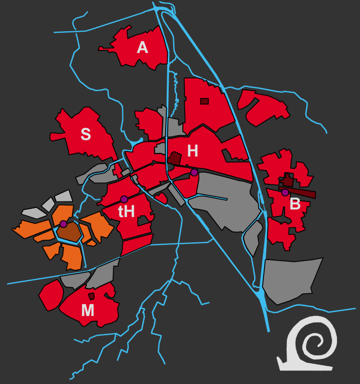
The Vinex-location of Brandevoort (in orange) within the context of Helmond (H), 't Hout (tH) and its "new-town garden village" Brouwhuis (B), and the villages of Aarle-Rixtel (A), Stiphout (S) and Mierlo (M). The large employment areas are typical of centralised Dutch urban planning focussed on compact settlements.

The master plan for over 6.000 new homes for some 17.000 residents and three industrial estates was structured as a central urban core with suburban sections around it that would tie in the new development into pre-existing suburban developments of neighbouring Helmond-'t Hout, Ganzenwinkel and Mierlo. The urban core was proposed as a small fortified city with canals. Developing the site meant that as compensation for the loss of permeable soil more surface water had to be provided. This is known in the Netherlands as hydrologically neutral development and has been practices for centuries. If one wants to develop a wet site or a site in the floodplain, one has to create more space for water, not less (!), to prevent future flooding. As a wet site (Brandevoort means as much as ford near a bog where peat is cut) provisions had to be made for additional surface water as two streams would have to be incorporated to prevent a nearby wetland nature reserve from drying up. 

The site was in part chosen as it was bisected by the existing Eindhoven - Venlo railway. Around a new train station for the commuter train Deurne - Eindhoven the urban core was projected with the moated "city" to the south and a high density extension directly to the north. Further north a three-part business park was projected towards the Eindhoven - Helmond dual carriageway. South, east and west of the "city moat" several suburban neighbourhoods were drawn; each resembling a garden village in layout. To ensure variety numerous architects have been employed to design the houses to be built by a consortium of developers. This sounds like a logical step, but the underlying reason is that thus the whole project can be divided amongst the several developers, that can each employ their own team of architects.

Work started in 2000 and is supposed to finish in 2022 (pre-downturn this was expected to be 2017). The train station Helmond-Brandevoort opened in 2006. At the same time the residents of 't Hout voted to rename their suburb to Mierlo-Hout to reflect the historic ties with neighbouring Mierlo. The name of the train station -opened in 1992- remains Helmond - 't Hout. A ring road for Helmond is also part of the plan for Brandevoort. The connection to the A270 dual carriageway was completed as part of the first building phase of the first phase of development. The housing followed the building of the road and water infrastructure. In 2011 the second connection on the A270 was opened as part of the last building phase of phase 1. The second phase of the development has started and will see the development of more housing and the business park.

Brandevoort is seen as the best example of New Urbanism in the Netherlands. The planners combined the cornerstones of Dutch planning (i.e. compactness by intensive land-use, mixed housing in type and tenure, clear zoning of functions, maximum permeability for slow traffic, counteracting through traffic in residential areas by a hierarchal road system and including surface water and the drainage system from the beginning) with the aesthetic approach of Postmodernism by consciously avoiding functionalism in the design of public spaces and buildings. The design follows the modernist urban fields approach and combines it with the German green fingers approach. The result are clearly defined (sub)urban areas both spatially and stylistically. Each area has been given a narrowly described profile concerning type of housing, building height, appearance, materials to be used and streetscape. These profiles are captioned under a theme, making this development a dream for both developers and real estate agents as they can market an ideal and provide a sense of choice within concise  parameters, something most consumers prefer.

The layout of Brandevoort consist of the central urban core where the facilities will be located: "De Veste". This name meaning "fortification" evokes the theme of the urban core of the development, which aims to give the impression of a 17th century fortified city complete witch canals and historicising architecture. In the marketing Brandevoort is portrayed as an ideal new village, probably as marketing people have been used to doing so for all Vinex-locations.  This central city has a central square, canal, gate buildings and walls with a moat. The street names are also historicising with the central square named Plaetse (literally Place) a name historically linked to a village green in Brabant. Also some narrow city streets were named avenue (Biezenlaan, Statenlaan, Middellaan and Herenlaan) which is another misnomer as an avenue is a wide tree lined street in an urban context. This fake historic town is however well-designed with pleasant streets and public spaces and a well-defined edge and entrances. The urban core north of the station is yet to be built; it will reference 19th century urban extensions. The idea is to produce monumental and stately houses here.


Brandevoort with its themed urban field ach consisting of a certain type of housing that references a historic style and/or type of buildings. The plan comprises of six "Buitens" and two high-density areas: Schutsboom (1), Brand (2), Stepekolk (3), Hazenwinkel (4), Liverdonk (5), Kranenbroek (6), and the urban core of the Veste (7) with De Marke (8) north of the station. Along the dual carriageway (A270) a business park (9) will be developed. The Schootse Loop (SL) a small stream is incorporated into the plan as well as a power line (PL) that was moved to run along a belt road. A medieval chapel of St Anthony (C) was incorporated into the first of the Buitens. Brandevoort sits next to Mierlo-'t Hout (MH), Ganzewinkel (GW) and on the other side of the Eindhoven Shipping Canal (E) Mierlo-North (MN).

The urban core is surrounded on most sides by suburban sections known as Buitens, each separated by green fingers where the landscape can penetrate up to the moat and wetlands around the urban core. Each suburban section is an urban field with a specific theme that translates into a specific type of architecture. Spatially these suburban areas are fairly similar. In places older buildings have been incorporated into these urban fields. This is very notably the case in Schutsboom, Stepekolk and Brand (the old farms of Brandevoort). The name Buiten is actually a misappropriation here as it normally refers to a country estate and not a suburban housing estate.

Each suburban section is filled with a certain type of nostalgic architecture. The Schutsboom Estate was the first of these "Buitens" to be developed. The buildings reference vernacular architecture of the 1920s and 1930s. A small extension has been developed with houses resembling  thatched farms. The neighbouring Brand Estate is characterised by so-called colonial housing in a New-Holland style with balconies weather boarded facades and porches. In Stepekolk all houses have red tiled roofs on low buildings that reference historic farms. The effect is very similar to the Alt Siedlung Friedrich Heinrich in Kamp-Linfort (built from 1907 onwards). The "Buitens" of Hazenwinkel, Liverdonk and Kranenbroek are yet to be built. Liverdonk will be the first. Here semidetached and terraced housing and some apartments will be developed in an effort to create a small town feel, inspired by the historic town of Thorn. Neigbouring Kranenbroek Estate will be developed with similar housing but with higher buildings that will often have white facades. Hazenwinkel will be developed with low farm-like housing in two neighbourhoods around a central park.  

The biggest problem with these centrally planned housing projects is that savvy developers had started buying land at the proposed sites before the decisions were finalised by central government. This takes many years of consultation after all, and developers can act quickly in buying (an option on) land. The city of Helmond forced the developers to trade their land for development rights, so the local authorities could keep a tight rein on the project. The result is a very controlled development with clear quality control.

Thursday, August 4, 2016

New Urbanism or the postmodern take on developing our cities


Allegedly bored with all the boxes the International Style of Modernism produced post CIAM, some architects started to search for a more expressive design language. This style grew gradually between the 1960s and 1970s into a movement that was coined Postmodernism. It was especially prevalent from the 1980s onwards and still influences architecture and urban design today. The often monochrome, functional and formalised spaces and shapes favoured by architects of the International Modernist Style (not to be confused with early European Modernism, which could be decorative, shapely, expressive and often colourful) were regarded as stark, boring, to isolated from their context and prescriptive. Postmodernism was a movement encompassing art, philosophy, literature, design and architecture. Its idea(l)s are most legible in the work of architects. As a result Postmodernism is often regarded as simply replacing a reworked Bauhaus-aesthetic by a neo-eclectic use of form and ornament. And for a lot of the buildings in this style this is certainly true, I think!

Around the same time Postmodernism took hold urban design lost its way: creating confusing mazes of winding organic streets with cul-de-sacs, stand-alone developments aimed at creating contrast often in series and known as necklaces or multi-local hubs, or large urbanisation schemes that looked especially great from above, but lacked sufficient visual cues to guide visitors or make them into a place. This is strange considering Postmodernist theory expresses the ideas of Contextualism. Contextualism is centred around the idea that all knowledge is sensitive to its context, either factual or perceived.

The main aim for both postmodern architects and urban designers was -so it seems- to be expressive, witty, ironic, virtuosic, paradoxical, technically clever and ambiguous, not at all relating to the urban context. Especially early European Modernism reacts with subtlety to its surroundings, whilst both International Style Modernism and Postmodern favoured the visible spatial intervention. It is often only at a building level that both styles express contextuality. In Postmodernism this is mostly achieved with materials, colour, form, and by citing details and ornamentation from the buildings in close proximity. A good example of this is the Inverdan Project in Zaandam.

As a reaction to the endless sameness of many suburban developments in the United States of America and the (often failed) redevelopment of urban areas, a movement towards greater urbanity arose. This was in part incited by Jane Jacobs' book "The Life and Death of Great American Cities" of 1961. Jane Jacobs is remembered as an advocate of mindful urban development as she argued that cities are living beings and ecosystems that were by definition of mixed use. New Urbanism arose in the USA in the early 1980s as an urban design movement promoting walkability, cyclability, mixed use developments, mixing housing types and a neighbourhood approach. New Urbanism is strongly influenced by pre-WW2 planning models and tries to counter the strong influence of transportation by automobile on the planning practice.

New Urbanism is basically community based and focuses strongly on the neighbourhood unit as the scale of intervention. The movement advocates the benefits of urbanism (as opposed to suburbanism or urban sprawl) from a multinuclear centralised perspective. It promises a better quality of life for residents, with a healthier lifestyle, more meaningful relationships within the local community, more diversity and more open space beyond the urban environment to enjoy. This is basically the same idea as that central to the Garden City Movement, but with much higher, but not extremely high building densities!

The 10 principles of New Urbanism are: 1] walkability, 2] connectivity (of networks), 3] mixed-use and diversity of use, 4] mixed housing, 5] quality of architecture and urban design (creating a sense of place), 6] traditional neighbourhood structure, 7] increased density, 8] green transportation (this means no cars basically), 9] sustainability (the eco-element) and 10] quality of life.

In some instances New Urbanism has been misappropriated by developers and architects to diffuse protests against gentrification and redevelopment. The more lasting influence of New Urbanism on the planning practice has been the emphasis on Transit Oriented Development. This is especially true in the vast sprawling cities of the Americas, as the system has been used for many decades in Scandinavia. It is, again, a planning device borrowed from the Garden City Movement to realise a different aim. By planning public transport systems where you want urban development to concentrate, this (re)development can be directed towards a more compact, higher density urban environment.

In Europe New Urbanism has fused with certain veins of Postmodernism (sometimes -superfluously as far as I'm concerned- known as PostPoMo or MetaMo) into either an environmentally friendly take on urbanisation, or an aesthetic approach which favours a return to pre-Modernist architecture. Especially in the Netherlands and Denmark an urban environment conducive to cycling and walking has been part of the planning practice since the 1970s. So that very American aspect of the movement had no place to land in the urban design practice. Even in the United Kingdom, where compactness was favoured over sprawl as a result of a planning regime based on the principles of the Garden City Movement, New Urbanism is mostly a push for eco-towns and promoting cycling, walking and public transport.

Most ecological development in Europe however are to low-density to be classed as an exponent of New Urbanism. EVA-Lanxmeer does share the primary focus of New Urbanism on walking and cycling combined with a favourable position near a train station. The nostalgic vein of New Urbanism, which wants to restore a recognisable urban environment with reimagined traditional architecture. Many neighbourhoods developed in America are felt to be a stage set, artificial and manufactured. I feel some of the European examples (although these are few in number as compactness is favoured by the planning systems) are more genuine. That said, many people disagree and feel these developments are little more than a pastiche of 1930s garden city housing or traditional town architecture.

Monday, August 1, 2016

Urban nature: on the wall, vertical specialists


The true nature of the city, with all its brick, stone and concrete, makes it very different from the surrounding countryside. This is especially true of water cities that were built in drained swamps and along rivers e.g. Utrecht and Antwerp. There the urban environment provides the ideal growing conditions for plants that normally thrive on exposed mountainsides and along small streams running down rocks. As such cities provide the ideal growing conditions for plants that aren't naturally found in the Low Countries. They have grown in this urban environment for so long that they have become established in their own little niche... literally!


This Crested woodfern (Dryopteris cristatus) has colonised a crack between the stones of a retaining wall in a park (on the left). The watered lawn behind provides an ideal growing environment with a steady supply of moisture for this wetland native. A fern associated with mountainsides is the Spleenwort (Asplenium trichomanes). The Dutch name of this little fern (Steenbreekvaren) translates as stone crusher, as it was believed to be able to bring down city walls and bricked embankments. It enjoys north facing walls with loose mortar. Rock fumewort (Pseudofumaria lutea) originated in the Alps and was introduced as a garden plant into the rest of Europe. As the name suggests the plant in the poppy family enjoys to grow in places with little soil. It can quickly invade a suitable habitat, especially shady walls. It can be found growing in many parks and on many a cemetery wall. 


Another plant only found on walls is the Ivy-leaved toadflax (Cymbalaria muralis). It originated in the Alps and the mountains of central Europe. Beyond its mountainous motherland it grows exclusively on walls and in loose pavements. The Wall-rue (Asplenium ruta-muralis) doesn't look like a typical fern. This lithophyte is mostly found growing on old walls hence the German name Mauerraute and the Dutch Muurvaren (literally wall fern).The Hart's tongue fern (Phylitis scolopendrium) needs a calcareous en moist environment to thrive. It is often found on canal walls, but has recently been discovered growing wild in woodlands in the Flevopolder with its heavy chalky clay soils.