Showing posts with label Waterschei Genk. Show all posts

Sunday, July 14, 2013

Mining colonies: mixed vernacular in the garden suburb of Waterschei


The earliest housing built for workers consisted of Mulhouse Quadrangles that were situated to the side of the colliery site in two long rows. The buildings have a distinct Walloon character in their architecture.


At the centre of the first mining colony at Waterschei a large executive villa (on the right) was built set within a large private park. Next to it on either side of the Parklaan two large villas were erected for the mining engineers in charge of sinking the pits. They are mirror images of each other. Both are built in the same Walloon vernacular as the Mulhouse Quadrangles; brick with the typical bands of natural stone and slated roofs. The white rendered villa  sets itself apart rather deliberately, both in architecture as in placement within the grid.


The massive building of the mining seat was built to impress with a fortress like tower and large central hall. It housed the several offices, technical department, changing rooms and baths.


The villas that were built along the Onderwijslaan and André Dumontlaan either follow the English vernacular akin to the architecture of Raymond Unwin (on the left), or display an ornate variation on Flemish brick vernacular combined with the projecting eaves of the Walloon vernacular.


In a small section of the garden suburb buildings have been built with a strong English influence. They are typed as cottage style buildings in Belgium, although they are better characterized as arts and crafts inspired.


The so-called cottage type buildings are to be found in the northeastern part of the Cité André Dumont. The belt road (Ceintuurlaan) forms the backbone of the garden suburb and consists of several sections, all planted with large trees in wide green verges.


Another example of the "cotage style" buildings with their partially rendered facades and composite roofs. Most are four family dwellings called Vierwoonst in Belgium. By varying the surfaces executed in either brick or light render corners are emphasized.


Next to the church a villa in the so-called cottage style stands in a lush garden. The Church of Christ the King itself dates from 1934 and stands out with its yellow brick facade. It was meant to stand out. It does so not only by virtue of its colour, but also the style of architecture implemented is rather austere and almost modernist in its plasticity and construction (reinforced concrete modules).


The large school building houses both a primary school, a kindergarten and a crafts school. The building is currently (2013) being refurbished. Its fort like appearance supports the ideal of a sheltered learning environment for children. The building has a large covered gate  and even a tower, making it a castle for learning.


To house the single workers and later the immigrants who came to Waterschei without their family the colliery built several hostels, called Hotel. One is now a mosque, the others are being converted to apartments. They are all built in a similar style. Here the Hotel Continental (completed 1925).


The short terraces are all situated along the winding streets along a fixed building-line with the occasional block set back according to Unwinesk garden city principles. This small church sits at the point where three curved streets meet and open up into a large expanse of grass planted with trees. The building is both known as the Josef Slipyj Centre and the Ukrainian Catholic Church of Saint John the Baptist.


At the corners special building types were used to strengthen the spatial composition. These buildings either folded inward (such as this example) to hug a corner, or folded outward to emphasize a curve.


Most houses are short terraces of four family houses, some are detached (right) or semidetached (left). Occasionally there are also terraces of three at Waterschei. These date mainly from after 1928.


These buildings along the Hoevenzavellaan conform to the overall type built in the garden suburb at Waterschei. They are part of a later extension between this central axis of the Zwartberg colliery and the belt road of the Cité André Dumont.


The buildings south of the Onderwijslaan vary from large semidetached to large detached properties in the earlier "cottage style" or the later vernacular style (left). These buildings housed middle management of the Waterschei colliery.


The buildings in the 1930s extension south of the Onderwijslaan are of the same type as the buildings in the western extension. The gardens are smaller though.


The buildings in the post-WW2 Tuinwijk-Zuid are similar in style to the neighbouring 1930s neighbourhood, albeit somewhat simplified in the detailing. The electricity building has been built as an ornate miniature stronghold complete with tower. From this tower the cables distributed the electricity throughout the neighbourhood. The mine company provided all the houses with electricity right from the beginning.


One of the iconic roundabouts in the Tuinwijk-Zuid. The whole is very formal in layout only the simplest of means are utilized to provide a little bit of variation such as these roundabouts with houses at an angle and the middle block of a row a terraces being placed further back from the road.

Friday, July 12, 2013

Mining colonies: Tuinwijk-Zuid Waterschei


On the Stalense Heide the Waterschei garden suburb was extended after WW2. This was done by extending the central avenue to meet the extended avenue of Zwartberg at an older road that once ran across the heath (now the Emiel van Dorenlaan is part of this older route). This extension was aligned with the central avenue and consists of 3 parallel streets at a right angle to it. The streets are connected by side streets, although these have no building on them. Where the side streets connect to the main streets a large roundabout has been put in place with a public garden or grass at its heart. The houses are mainly terraces with 4 dwellings. They are placed along the streets at regular intervals. At the roundabouts the houses have been placed at a 45o angle. The whole setup is formal, but this is softened by the buildings that have varying details, roofs and facades.


The Tuinwijk-Zuid (1) is a formal neigbourhood directly south of the extended axis of the garden suburb of Waterschei. It was built in a single building campaign. North of the garden village large villas (2/3) were built along the extended Onderwijslaan. Between the Tuinwijk-Zuid and the Stalenstraat a number of bungalows (5) were built after 1960. The rest of the buildings (4) differ greatly in apperance and style. They were constructed between 1950 and 2000.

The Tuinwijk-Zuid was developed immediately after the war in 1947-48. The street names are commemorative in nature Bevrijdingslaan (Liberation Avenue) and 14 Septemberlaan (the date Genk was liberated). The backbone of the neighbourhood is the central axis formed by the Verbindingslaan (literally: Connection Avenue). The side streets have no separate name, as there are no houses on them. The layout is reminiscent of the parallel lanes with Mulhouse Quadrangles. The spacing is indeed similar. It seems like the street pattern was to be extended further west. This never happened though. Instead we see a mixed neigbourhood consisting of the typical urban sprawl along former paths and preexisting roads. This urban sprawl together with the post-war neighbourhood and the 1930s neighbourhood behind the hospital are now called Tuinwijk-Zuid (Garden village South).


Taking a closer look at the morphology we see two old routes (shown in orange) and a slightly skewed block of cultivated former heathland divided into broad strips (shown in yellow). The large garden suburb Cité André Dumont bordered on this large block of land. The Tuinwijk-Zuid crosses into it and alters the alignment. The new pattern of three parallel streets connects to the preexisting paths and roads. The two main avenues of Zwartberg and Waterschei (in red) meet at an older road. In the 1970s a motorway was constructed with a new express road connecting Zwartberg to Genk via Winterslag (shown in violet). Because of this express road older streets were dissected and eventually parts of old routes were discontinued.


The garden suburb at Waterschei in Genk has been developed out of several neighbourhoods all typical for their period, but still the whole makes for a beautifully conceived residential area reminiscent of English garden city examples.Tuinwijk-Zuid differs in layout and building style. It makes up a small portion of the total garden suburb.

Monday, July 8, 2013

Mining colonies: Cité André Dumont


Work at the Waterschei-site started in 1909. At the end of that year the railroad on As was completed. It started at Zwartberg, a former testing ground for anti aircraft defense cupolas, and connected to the main railway Hasselt-Maaseik (completed 1873). At first it was an industrial goods track. With the extension of the railway to Winterslag in 1925 a passenger service was started. This meant that train stations were needed. These were built where before simple goods sheds and platforms had stood. Both stations are located next to the spot where an old route crosses the railway track.


The mining colony has a differentiated layout completely separate from the older landscape. The older settlements of Heppenzeel (1) and Waterschei (2) lie south of the large garden suburb but have little connection to it besides the historic Stalenstraat (3) and the newly cut André Dumontlaan (4). In the west the edge of the  colony corresponds to a number of large parcels on the Stralense Heide (SH). Besides the offices (O), pit towers (P), train station (T) and the large villa (V) of the colliery executive, the garden suburb has amenities such as hostels (h), a hospital (H), a school complex (S), a small park (p), two churches (K) and a culture club named 'Casino' (C).

The site chosen for the new colliery lay on the heath bordering the hamlet of Waterschei. A specialized workforce had to be brought in to sink the two pits and construct the mining rail tracks and the first functional buildings. A large tract of land was acquired for the colliery and an accompanying housings district.  Both colliery and mining colony were named after André Dumont, who initiated mining near As.

The development of the Waterschei garden village is predominantly the work of architect Gaston Voutquenne. Before he arrived at Waterschei engineer J. Verwilgen had planned a strict grid with parallel streets (1912) along which the new housing would be built. During the first building phase of the Cité André Dumont construction started near the main seat of the mining company with rows of Mulhouse Quadrangles for the workmen sinking the pits and villas for the higher echelons, including the imposing executive villa. The new housing was organized hierarchically, both in location as well in the internal layout of the dwellings.
Due to limited financial means and the First World War, building activity in Waterschei came to a temporary halt between 1914 and 1918.

During the 1920s the extension of the mining colony was resumed; this time under the auspice of Voutquenne. The stark grid of the industrial cité charbonière was abandoned by Voutquenne in favour of the garden city idiom. He designed a garden suburb in which winding roads and attention to greenery were aimed at creating a stimulating and agreeable environment for the miners. The axiality of the grid was replaced with a large curved loop that connected the ends of the main streets of the earlier grid. This layout closely follows park design of the period with a belt walk and winding paths within this perimeter that crossed off centre. The Belt road of the garden suburb was appropriately named Ceintuurlaan (a ceintuur is a belt or girdle). By July 1923, the garden suburb had 320 dwellings for workers and middle management, with some ninety more homes under construction. All the public facilities such as water, electricity and sewerage were included. 


It is often stated that the Cité André Dumont has been built in three building campaigns, the first in 1912, the second in 1925 and the final in 1947. This can clearly not be true when the urban morphology of streets and buildings is taken into consideration. The first building phase, the colony proper, (shown in deep red) probably ran from 1912 to 1915 and conforms to the colliery grid. The second building phase ran between 1920 and 1925 (shown in bright red) and encompasses the larger part of the garden suburb. An extension (shown in tangerine) was made somewhere between 1924 and '28 on the west side of the belt road. Around the same time amenities were implanted. Somewhere between 1930 and 1935 two further extensions (shown in orange) were made linking the garden suburb to the Stalenstraat and the neighbouring Zwartberg mining colony.   

At the end of the 1920s and mainly during the 1930s the garden suburb was extended beyond the belt road towards the west and south. In developing his plan Voutquenne looked to find a connection, particularly to the Stalenstraat, to the Waterschei train station and to the neighbouring Zwartberg mining colony.  The small neighbourhood behind the hospital (1928) was built to link the garden suburb to the Stalenstraat (which had developed into a commercial street with a variety of shops). This extension conforms to the older grid.

To the west two circuits were subsequently added to the belt road, connecting the Cité André Dumont with the central avenue of the neigbouring Zwartberg mining colonies. Both mining colonies were developed towards the edge of the landholdings. Thus the Cité  wasn't extended beyond the woodland on the Stralense Heide (Stralen Heath). 


The design for this large garden suburb marries the older grid (deep red) with a winding style reminiscent of garden design of the early 1900s. Part of the old grid is developed as broad avenues that frame the English inspired garden suburb. Where the two meet amenities and parks and sporting grounds are situated. The design of the garden suburb (in red) consists of a loop and an inner shortcut consisting of three curved roads. Where these roads meet large triangular public gardens are drawn in. All other roads are within the framework of these three curved roads and the two avenues. The extensions (tangerine) on the west side consist of two loops that cross and an angular connection to the main axis of the Zwartberg colony. The extension on the south follow the old grid again. This seems to suggest the older parceling was still in place here.

Friday, July 5, 2013

Mining colonies: Waterschei Genk


The coalmine at Waterschei (that name literally means watershed) is one of seven in the Campine coal basin. The concession named André Dumont-sous-Asch was granted in 1906 after André Dumont had found coal in the village of As (Asch in French) in 1901. The village counsel of As rejected the foundation of a colliery within its borders as they feared large scale immigration, pollution and negative effects on agriculture. The colliery was therefore to be located on the other side of the heath near the hamlet of Waterschei within the parish of Genk on the edge of the arable fields.

Work on sinking the first pit was started in 1912 using the Foraky-method. The work was troubled by set-backs resulting in the pit being completely flooded in 1914. Work on sinking the second pit was started during the first half of 1914 without many problems. Work on both pits was suspended during the Great War to be completed in 1922 (pit 1) and 1928 (pit 2). The first coal was extracted in 1924. Both pit towers are identical and date from 1922.  Between 1920 an 1924 a large representative office building with large hall, bathhouse, changing rooms, directors suite, administration, payment counters and lamp distribution counters was erected on the edge of the site near the Stiemersbeek, a brook that was at first brought underground and now feeds a series of ornamental ponds.


The offices of the colliery were housed in this imposing structure with a tower on the corner and an enormous central hall over two floors with a large window on the front facade. The pit towers at Waterschei were constructed by the Societé Anonyme de Construction et de Chaudronnerie d'Awans from Bierset-Awans near Liége in Wallonia.


The colliery site was initially organized using a grid layout. Housing for the pit workers and engineers was provided on the edge of the site. This housing took the form of Mulhouse Quadrangles and detached and semidetached villas along the Meridiaanlaan (i.e. Meridian Avenue). The villa for the director is located at the centre of this housings strip in its own park like garden. These buildings were erected between 1912 and 1914.  


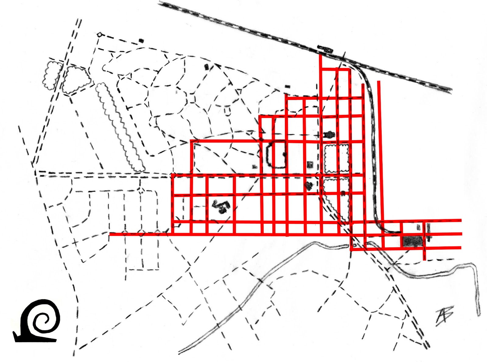
The original grid of the colliery forms the basis for the area around the Meridiaanlaan and the production site itself. What is surprising is that the later garden village layout in part also uses the old grid and transforms it. This is clearly visible when the gridlines are projected on the street pattern. Especially the amenities (church, school and tennis courts) still have a link with the grid. The director's villa is placed centrally on the crossing point of two gridlines.


After 1920 plans were drawn up for expanding the mining colony. To this end the André Dumontlaan and Duinenlaan were constructed to link the site to the thoroughfare Genk - As. The Genk-Waterschei train station was built at the end of the Duinenlaan (Dune Avenue, as it lead to the heath) in 1925. Perpendicular to the Duinenlaan (and thus the older colliery grid)  a new broad avenue was planted: the  Onderwijslaan. This avenue ended abruptly at the point where the belt road of the garden village called Tuinwijk André Dumont starts. This Ceintuurlaan curves back to the Duinenlaan. The Binnenlaan  (literally: Inner Avenue) divides the garden village east - west. The streets follow a curved alignment reminiscent of park design of the day. South of the Onderwijslaan along an existing route along the Stiemerbeek called Stalenstraat (named after the medieval mansion of Stalen) developed into a commercial district serving the garden village. There was no space allotted for commercial venues (shops, bakery, barber, greengrocer etcetera) within the garden village. Here only amenities were planned and provided buy the mining company. This pattern is seen in all Campine mining colonies.


The street pattern of the garden village follows a simple plan with two avenues along the older grid connected by a belt road (Centuurlaan) and divided by a secondary central road (Middenlaan). The edge of the garden village was determined by the Stalenstraat to the south, the railway line to Zwartberg in the north and the Hoevenzavel to the west.


Between the Stalenstraat and the Onderwijslaan the Tuinwijk-Zuid was developed. It follows a strict street layout of parallel main streets with roundabouts connecting the side streets. After 1944 the central avenue dividing the garden villages to the north and south was extended to join the extended central avenue (Hoevenzavellaan)of the Zwartberg colliery.


After the grid had been abandoned in the 1920s it resurfaced around 1930. We see this in the small development between the Onderwijslaan and Stalenstraat around the Eeuwfeestlaan (i.e. Centenary Avenue, that was celebrated in 1933) and even more pronounced in the post war extension west of it. All streets run parallel and are named in commemoration of WW2.