There are eight examples of Saxon Borg-tows in
Twenthe, that all share similar spatial characteristics. Two of these never
grew into a "proper town": Goor and Diepenheim. The other six -
Oldenzaal, Rijssen, Ommen, Ootmarsum, Enschede and Delden - grew into small
town that sometimes expanded considerably with the industrialisation of the
late nineteenth century. Most however have remained small market towns often
with an imposing castle or Havezate (Manor house) in close proximity. The firstfour examples have been discussed in Part 1, the other four will be discussed
below.
Ommen
Near a ford on
the Vecht river on a river dune a settlement grew. The name is probably derived
from öne or une and means "place by the small river". On the edge of
the higher ground a stronghold was constructed to protect the river crossing.
The Bishop of Utrecht imposed a river toll on the Vecht. As a result the
settlement near his manor grew. So it was decided to expand the settlement. To
better facilitate this the bishop granted Ommen city rights in 1248. the
settlement was expanded northwards in a regular fashion following the regular
parcellation of the land. In 1382 Hugo van Verssen receives the manor of 't
Laer of the bishop. Sometime in the previous century the bishop had moved his
seat from the town to a new location south of the river. A country house on
moated site with a formal garden still
stands here.

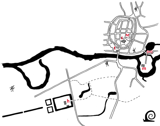
The planned town of
Ommen sits on higher ground near an important river crossing. The town hall (t)
is also located near the bridge. The church (c) stands close by with a market
(M) laid out directly adjacent to the former stronghold or borg. On the river
Vecht the oldest watermill [m] was replaced by another watermill (m).The manor
house (h) of 't Laer is situated south of the river.
Ootmarsum
Around 770 one
of the earliest churches of Twenthe was built in on the compound of a local
chief who also gave his name to Ootmarsum (the place name means: Homestead of Otmar).
In 917 St. Radbod dies in Ootmarsum. The moated and fenced church freedom thus
gains importance and a service settlement grows around it. In 1196 the Drenths
plunder the village and burn it to the ground. Between 1200 and 1400 a new
-enlarged- church is built.
In the
thirteenth century several noblemen from Twenthe bequeath land to the Teutonic
Knights. In 1262 an outpost of the central Bailiwick in Utrecht is founded in
Ootmarsum. It is located on a moated site just outside the village. The choice
for Ootmarsum was probably actively supported by the bishop as it made it
easier to control this remote corner of his domain. On the moat a large
watermill was built, with a second one further downstream. With the Teutonic
Order in place the old stronghold is abandoned.
Around 1300
Ootmarsum receives its city charter from the bishop. So an outer moat is dug
and earth banks are raised. The moat is fed by a channel from the nearby marsh
called the Mos. A space behind the church is designated for markets, but proves
to small so a new market is created within the town, resulting in two market
places.
Ootmarsum is a lovely
example of the iconic Borg-town pattern with the church (c) within the confines
of the former borg and central in the town. Near the church a market (M) has
been laid out with the town hall (t) directly on it near the church. A seccond
market and church are located on the edges of the town. Directly outside of the
towns defences a manor house (h) stands, here directly adjacent to the watermill
(m).
Enschede
There are no
written records of the early history of Enschede, although it is clear from
archaeological finds that there was a borg or stronghold on higher ground
between the Roombeek and Glanerbeek, two small rivers. The stronghold lay central
to the Marches (Marken in Lower-Saxon) of Usselo, Esmarke, Driene, Lonneker and
Twekkelo. The name Enschede also means on the border (the place where the
separate Marches met). These marches fall under several overlords: the bishop
of Utrecht, Werden Abby or the Maltese Knights of Bergsteinfurt.
The former
stronghold of Esmarke lies at the heart of the historic city. Here a grain
store, barn and stables were built to collect the tithes. Next to this a
shield-shaped church freedom was marked out around which a settlement grew. In
1319 the bishop grants a town charter that includes the right to host markets,
raise taxes and built a defensive wall. A moat is excavated and a paling raised
on top of an embankment that encircles the existing settlement. The settlement
was already surrounded by a fence before 1300 (as there is mention of two gates
at that time). In 1325 the city receives full city rights as a court is
installed and a weighing house and trade hall are built. In 1465 a second
circular moat is completed. This moat is surrounded by a thorny hedge. The borg
had been demolished by 1449 as it had lost its defensive function. In 1535 a
local nobleman builds the Nye Borgh in the southern corner of the city. Around
1600 the defences are dismantled and the town sleeps until textile
manufacturing and other industries create rapid growth after 1860.

In Enschede the oval
shape is indicative of it being a Borg-town, but here the former defensive
mount of a borg-keep is still visible behind the town hall (t). As an important
town there are three churches (c) and two markets (M). The watermills were
located at some distance in the Marches.
Delden
This place is
first mentioned in 1036 when the bishop of Paderborn grants his manor or estate
(praedium can mean both) of Theldene
to the collegiate church of Busdorf. It is likely that soon after a chapel or
small church was built on the edge of the estate. This church and the tithe was
gifted by the bishop of Utrecht to the collegiate church of St Peter also in
Utrecht in 1118. This means there was a manor or grange here that fell under
the dominion of the bishop. In 1294 the collegiate sells its property on to the
collegiate church of St Lebuin in Deventer. As the collegiate church of Busdorf
sells its property in 1239, both are different entities. there is clearly a
large landed estate called Delden that can be equated to Deldeneresch, a number
of Marches on a fertile ridge of land and a stronghold the edge of the ridge on an old road that
must be located around the Church of St Blaise. Saint Blaise is the patron
saint of Paderborn, making it likely that they are responsible for the
foundation of the first church.
The stronghold
with grange and church would have been surrounded by an earth bank or paling.
To expand the grip on his dominion the Bishop of Utrecht grants special rights
modelled after Oldenzaal on what he calls Nyedelden (New Delden) in 1333.
Around the original compound a wide encircling moat is dug and an earth bank
raised: with a paling on top and a thorny hedge at the foot of it. A new market
place is laid out and on the landed estate (that had come in the possession of
a fief of the bishop) a new grange was erected known as Erve Hofmeijer
(Farmyard of the Sherriff). The new vassal was Herman of Twickelo who expanded
his property House Eysinc into the caste Twickel that now stands in the former
marsh at the foot of the fertile ridge.

The small circular
town of Delden occupies an area far smaller than the neighbouring estate of
Twinckel Castle (h). The oval moat and bank encircled a small Borg-town with a
church (c) at the site of the former grange. The market (M) is located directly
adjacent. The town hall (t) stand on the main thoroughfare.