Wednesday, July 30, 2014

Getting around... Antwerp


Antwerp promotes itself as a pocket-size metropolis of 510,000 inhabitants. About a fifth of the historic centre has been pedestrianised and the city is currently rolling out a program of cycle lanes and one-way streets inspired by Dutch practices. Belgian cities are seldom easy to navigate by car, so it makes sense to give priority to walking and cycling as a means of getting around within the urbanised area. Antwerp is connected to the rest of the country and even the rest of Europe by several train lines, some high speed. The city has a web of public transport lines reaching all corners of the conurbation. The network comprises of bus and tram, both exploited by De Lijn (literally The Line). The underground sections of tramlines are knows as pre-metro.


Antwerp also has a bike-hire scheme known as A-Velo which is similar to the one in Brussels called Villo!, but with slightly different bikes and different colours. The bikes can be collected from any one of the 145 bike stations (left) dotted around the city. The trams (middle) run through the city centre and some of the neighbouring suburbs. The bus (right) is the more common way of connecting the centre to the outlying areas though.

Monday, July 28, 2014

Kielpark: stacking housing units to create space


The de facto motorway called Jan DeVoslei has been covered with two one-way streets along a central strip of greenery and paved areas. The middle-rise apartment blocks stand proud on either side of this rather underused public space. Most of the blocks have been placed at an angle to the road to take advantage of natural sunlight.


Behind the middle-rise blocks along the road amenities like a school (shown left) have been built. The placement of the middle-rise block at an angle creates a rhythm along the Jan DeVoslei (right) but also allows the parklike greenery to penetrate every corner of this neighbourhood.


The building have been designed as freestanding slabs. Most have been built in a similar manner using the same details and materials. In the southern part we see some building that have a different skin with a combination of concrete panels and bricks. These buildings are from the second building phase and were designed by Maes.


The middle-rise blocks by the architect Smolderen are grosso modo the same, except for small details, mainly on the ground floor. Here coloured tiles are used to set each apartment block apart. These tiles that range in colour from shades of blue via blue green to green, yellow and auburn can be of a different shape as well.


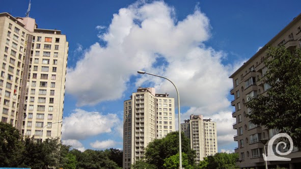
Behind the row of middle-rise blocks along the Jan DeVoslei three high-rise towers emphasise the transition to the actual Kielpark behind. By stacking more dwellings on top of each other more space has been created at ground level to integrate park and greenery between the apartment blocks. This creates a flow of space that works really well. Also the towers have less of a visual impact as they are further apart and enveloped by greenery.


The ground floor of each building has some well designed details that break the starkness of the overall design and add both colour and shape. The round windows in the tiles walls provide daylight to the communal spaces on the ground flour. The entrance has been designed to blend in with the rest of the ground floor from a distance, but stands out enough once one gets closer to the building.


From inside the Kielpark the middle-rise blacks are hidden by the trees, only the high-rises tower over the park. With the trees planted between the towers the park seems to stretch far beyond, creating the impression of endless space.


The high-rises are so-called "sterflats" that consist of three wings around a central core with an elevator and stairwell. Like the middle-rise apartment blocks (right) the buildings appear to be elevated on pilotis. In actual fact this is a smart design trick as the ground floor is mostly enclosed by a wall for the hall and other communal spaces with the pilotis forming a gallery around this.


The high-rises have been designed as bright towers with three identical wings where the structure has been used as ornament within the facade.


The area between the high-rise towers (left) and the middle-rise slabs (on the right) has been laid out as a parklike area with playing fields, grass, shrubbery, trees and parking-lots. The massive increase in car-ownership since the 1960s means that the parking spaces provided are to limited. This has lead to cars being parked left and right along roads and even on footpaths and pavements. It seems strange therefore that the entrance to the underground parking garage is overgrown and clearly disused.


The Kielpark is at the site of the former city cemetery of Antwerp. The area is elevated as the burial site had to be raised to be far enough above ground water (which is quite high as the site isn't far from the Scheldt river). The park has several sporting grounds and a large playground within it. The res has been planted as one would expect of a post-war public park with winding paths around a central open space laid to grass with trees around is as a green belt. The Kielpark has many purple leaved trees in it (Beech, Maple and Cherry Plum).

Thursday, July 24, 2014

Kielpark: an urban insert in Kiel, Antwerp


The Kiel district of Antwerp has been part of the city since the seventeen hundreds. Most of the villages of Hoog-Kiel and Laag-Kiel disappeared under the ramparts and bulwarks of the expanded city defences and now lie underneath the motorway that replaced them. Only the hamlet of Beerschoten remained. The name Kiel refers to a "kyle" a bay on the river Scheldt. The field of fire around the city defences meant that there was ample space here to host the 1920 Olympic Games and 1930 World Exhibition. Both sites were subsequently developed as residential areas. Urbanisation also occurred in a typically Belgian manner along pre-existing lanes and roads. This lead to a fragmented urban landscape of incidental developments alternating with planned large to medium size developments.

Especially after WW2 the city of Antwerp took a proactive approach to urban development to counteract de rapid suburbanisation in the villages and towns around it. This meant that wherever possible free spaces within the urban fabric should be developed, mostly for residential use, although offices were in some cases also built. The Kielpark neighbourhood is an example of such an urban insert.

Between 1952 and 1967 the Maatschappij de Goede Woning (literally: Good Residence Society), a social housing society, developed a new residential area between the Jan De Voslei and the Boomsesteenweg on a site near the former sites of the Summer Olympics and the World Exhibition. The neigbourhood consists solely of apartments of varying height set in communal green space next to the Kielpark; the park from which the neighbourhood took its name. The idea was the have the park flow into the residential area seamlessly. Alas the large areas now in use for parking have eaten away at the green space enveloping the buildings.

The park itself was planted on the former Kiel cemetery that was started in 1786 after a decree of Emperor Joseph II of Habsburg-Lorraine forbidding burials in inner-city churchyards . The cemetery quickly became Antwerp's main burial site and remained so until the Schoonselhof cemetery was founded in 1911 top cope with the increasing number of inhabitants of the city. The cemetery at Kiel was decommissioned from 1921 onwards and was returned to the people as a public park in 1952.

All buildings in the Kielpark neighbourhood are freestanding and measure 16, 7 or 5 storeys. The architect is J Smolderen, who -together with Hendrik Maes- designed compact and airy apartments in sleek block where the structure is ornamental. Especially on the ground floor elevation and around the doors extra care has been taken to create pleasant spaces. The neighbourhood has a communal  thermal energy plant and other amenities such as a recreational building with cinema and stage, cultural centre, playing fields, two schools and a daycentre for the elderly.


The Kielpark-neighbourhood is wedged between two pre-existing neighbourhoods on a long strip of land next to the covered motorway. On the left is the Olympic neighbourhood near the Olympic stadium (OS) that is very recognisable by its grid layout. On the right lies the Tentoonstellingswijk (T) on the site of the Great Exhibition of 1930. Towards the north lies the Kielpark (KP) a former cemetery turned urban park. The infill project is shown in black and consists of several apartment blocks and three towers on the edge of the park making the most of the available space.

Monday, July 21, 2014

Antwerp: building upwards to retain open space

After WW2 suburbanisation accelerated in Belgium, especially in Flanders, not only around large cities like Antwerp but also around towns and even small villages. One of the solutions proposed by the city council was to offer up parcels of land to developers and/or social housing societies. Infilling by developing undeveloped or underdeveloped areas within the urban landscape was the way forward so it was thought. Often these urban infill projects consisted of high-rise and medium-rise apartment blocks.  After the fusion of Antwerp with the surrounding municipalities of Berchem, Berendrecht, Borgerhout, Deurne, Ekeren, Hoboken, Merksem and Wilrijk in 1983 this tactic was rolled out across the hitherto often semirural to suburban fringe, but met which such fierce opposition that the plans were scaled down to medium-rise neighbourhoods that are so very characteristic of Antwerp.

Some of the high-rise neighbourhoods built between 1950 and 1980 are well known as prime examples of the work of the architects involved or as exemplary for a certain style of architecture. Examples are Luchtbal, Wooneenheid Kiel, Kielpark, Vinkenvelden, Kleine Heide, Pulhof and Bosuil.

In the twenty-first century building residential towers is proving popular with both politicians and developers. The most important argument for building these high-rises is that they occupy little space and therefore leave more space for the public domain or green urban space. The Antwerpen Hogerop pressure group goes even further, proposing a new tunnel for the motorway and the creation of a green river around the old city with several nuclei of high-rise buildings especially located around stations. The city of Antwerp also produced a policy document with the outlines of their approach to new high-rise buildings. This HoogBouwNota links the quality of the urban skyline to conservation issues, efficient use of space, considered densification, retention of open urban space and the large scale application of sustainable building methods. In the policy document the city outlines areas where high-rise buildings are not permitted, where they could be permitted if qualitative and quantitative conditions are met and where these buildings would enhance the skyline and are best concentrated. A towering building is defined as at least 50 to 60 metres in height. The building height restriction of 123 meters (the height of the cathedral spires) is retained for the future.


The infill projects are located mainly outside the old borders of the city of Antwerp (*), with a clear emphasis on the southern part in Kiel, Hoboken and Berchem. These projects include:  Luchtbal (L), Wooneenheid Kiel (W), Kielpark (K), Vinkenvelden (V), Kleine Heide (H), Pulhof (P), Fruittuin (F), Arenawijk (A), Jos van Geellaan (J) and Bosuil (B). Areas where high-rises are best concentrated according to the city council are: Nieuw-Zuid (1), Berchem Station (2),  Nieuw-Zurenborg (3), Central Station South (4), Eilandje (5), Linkeroever (6) and Luchtbal (7).